Jan and I have never visited Bryce Canyon. We drove through it with Dan and Elizabeth many years ago on our 3,000-mile camping tour of the West, we had spent a couple of nights tenting in Zion but then continued on our way to Dinosaur National Monument and points north. So we’ve been looking forward to visiting Bryce for a long time.
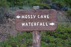
After breakfast we drive into the park, walk along the rim overlooking the first of a series of magnificent “amphitheaters” and head down the hiking trail toward Queen’s Garden. The woman at the hotel desk told us that we should do this hike in the morning, when the sun is low and lighting up the east-facing walls of the canyon. And we learn the Bryce Canyon is not technically a “canyon”, since it wasn’t cut by a stream running down its length, but rather by small rivulets and ice melt running perpendicular to its walls.

Walking down the amphitheater in the morning sun.
But canyon or not, it’s astonishing, the beauty of this place is indescribable! We’re stunned every time we turn a corner, or look up, or look back over our shoulder.
We pass dramatic stands of what appear to be alien sentinels, “hoodoos” (an African word), which bring to mind an odd recollection.

Hoodoos
After we arrived in Orange County from Australia in 1977 we often visited Disneyland, first with friends visiting from overseas, and later when our kids were little. One of our favorite rides was Big Thunder Mountain, a train/roller coaster racing through a desert Southwestern landscape. We only now realize that Disney closely copied the dramatic rock formations on that ride from the hoodoos we’re seeing here!

Jan on the "other"Wall Street
We continue past Queen’s Garden, past the cutoff for the Navajo Loop trail, and turn back toward the rim through the narrow confines of Wall Street. Hikers on this trail benefit from a fair bit of rock-cutting, shoring up and stair-building, much of the work was done not by the National Park Service, but by the the Civilian Conservation Corps. We have a sentimental attachment to the CCC’s, Jan’s dad (“Roz”) was part of the Corps before WWII, and there’s an old CCC camp on Mud Creek Road that we pass on the way to our Lake Vermilion cabin.
When we get back to the car we drive down to the very southern end of the park and work our way back past a series of spectacular lookouts.

Is it raining? Well, yes and no...
We’ve had gorgeous weather for our morning hike, but it’s not so reliable now. There’s only about ten-minute interval between the two photos above…

The Natural Bridge
…but we get a fine view of the Natural Bridge.

Ho hum, more of the same...
It’s time to leave Bryce Canyon. It almost seems redundant but I can’t resist throwing in one more landscape.

Goodbye to Bryce
The next morning we pack up our stuff, load it back into our trusty little Subaru and head out of the park. Some of the locals are out to say goodbye.

A corner of Lake Powell
We head south on Route 89 through miles of dry scrub, then we see some water in the distance. It’s our first view of Lake Powell.

Agave?
Not sure exactly what this is, but it clearly loves dry heat and it’s got beautiful seed pods.

Glen Canyon Dam
And here’s the famous (infamous?) Glen Canyon Dam with Lake Powell behind it. There was considerable opposition to building this dam in the 1950’s, which ended up flooding a deep canyon of stunning beauty. Lake Powell is very big, it took 17 years to fill.

The mighty Colorado River
The river looks pretty harmless, but it was this little guy that created the Grand Canyon a few miles downstream over the past six million years or so.
Utah’s behind us and Flagstaff is ahead, we continue on to Prescott to find the beautiful home of our friends James and Randy Williams with whom we’re going to stay for a few days. But one more adventure awaits us on the way.
I call James to let him know when we’re arriving, and he suggests an alternate and more scenic route from Highway 17 to Prescott than the normal one. However, as the saying goes, “What we have here is a failure to communicate”. James thinks he’s sending us on Cherry Road, but I think he’s telling us to drive through the town of Cherry, and we end up on W. Cherry Creek Rd. instead. I should have known something was wrong when the map on Jan’s smart phone showed the town all right, but showed no road leading to or from it. Here’s a satellite view of the route we end up taking:

The road through Cherry
We leave Highway 17 (at the upper right) and turn off onto a nice two-lane paved road, but after a while it turns to gravel then to dirt, then climbs steeply up a mountainside in a series of sharp switchbacks. We spend an hour and a half driving along this 15-foot wide strip of dirt with a frighteningly steep drop-off on our left and no barrier. At one point I ask Jan if I can stop to take some photos…but she tells me that if we stop she’ll have to get out of the car and she won’t get back in. So no photos. If the drop-off had been on her side instead of mine she would have been out of the car long ago. We pass a couple of well-worn Jeeps coming the other way, both drivers thoughtfully stop to ask if we’re all right – we obviously are completely out of place. I ask one of them, “Cherry is up ahead, right?”. His answer: “Yup…such as it is.”
We get to the top of the mountain and begin a gentle descent through the woods, Jan starts breathing again, and we go through the town of Cherry which consists of a few houses by the side of the road. We stop to let a young man lead a handful of longhorn cattle across the road. The dueling banjo theme from “Deliverance” is running through my head.
But we get to the end of W. Cherry Creek Road and turn right onto Cherry Road, then make our way to Prescott on the route that James had actually recommended, only a couple of hours later than expected. Our evening Manhattans have never been more welcome.


")